
How Space Weather Interferes with Our Communications
When the Sun Gets in the Way: Which Communications Technologies Are Most Vulnerable to Space Weather.

The Sun — Not Only Warmth and Light
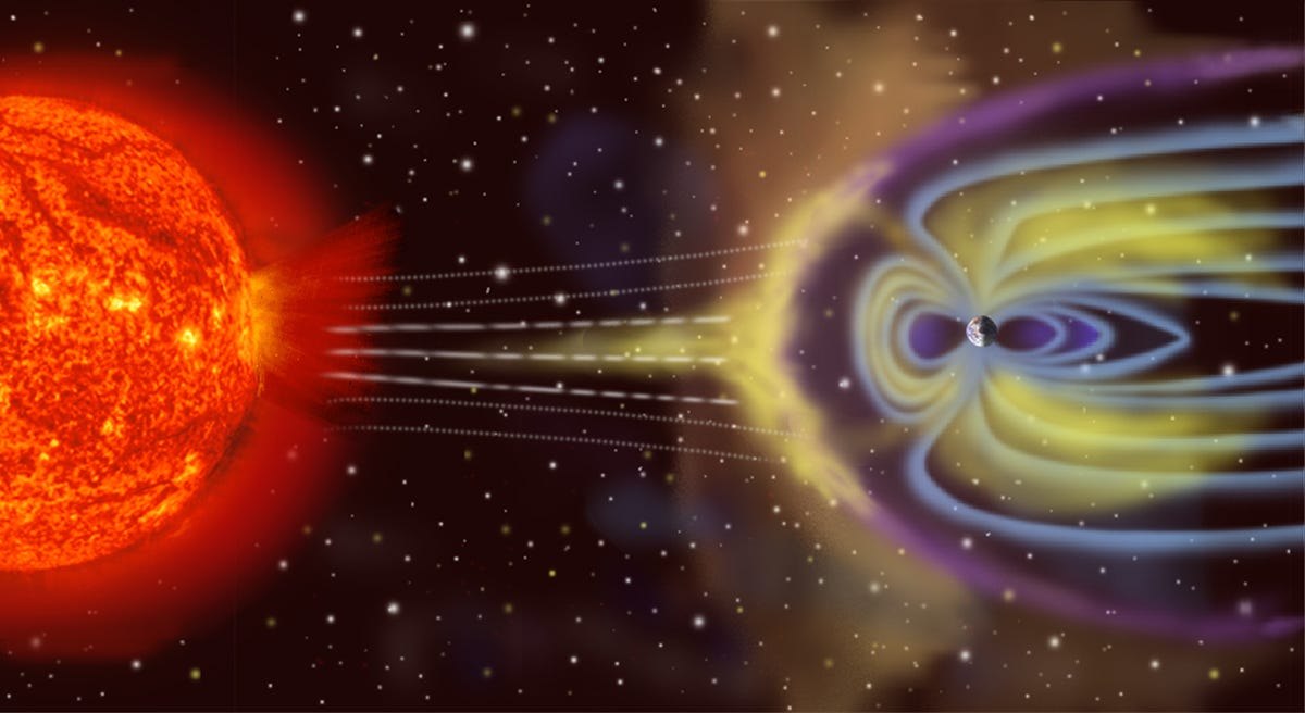
The Sun, like a noisy neighbor upstairs, can suddenly “turn on the drill” and at any moment make adjustments to our plans. Our star is capable of creating problems that most people don’t even suspect. We are talking about space weather — explosive events on the Sun that affect the ionosphere and the Earth’s magnetic field. This is not science fiction and not “scary tales for scientists” — it is a reality faced by aviators, the military, satellite network operators, and even internet users in remote villages.
An ordinary storm on Earth can blow the roof off, while a space storm can knock out communications. Let’s figure out where this is critical, and where we can sleep peacefully.
The Main Culprits of Space Mischief
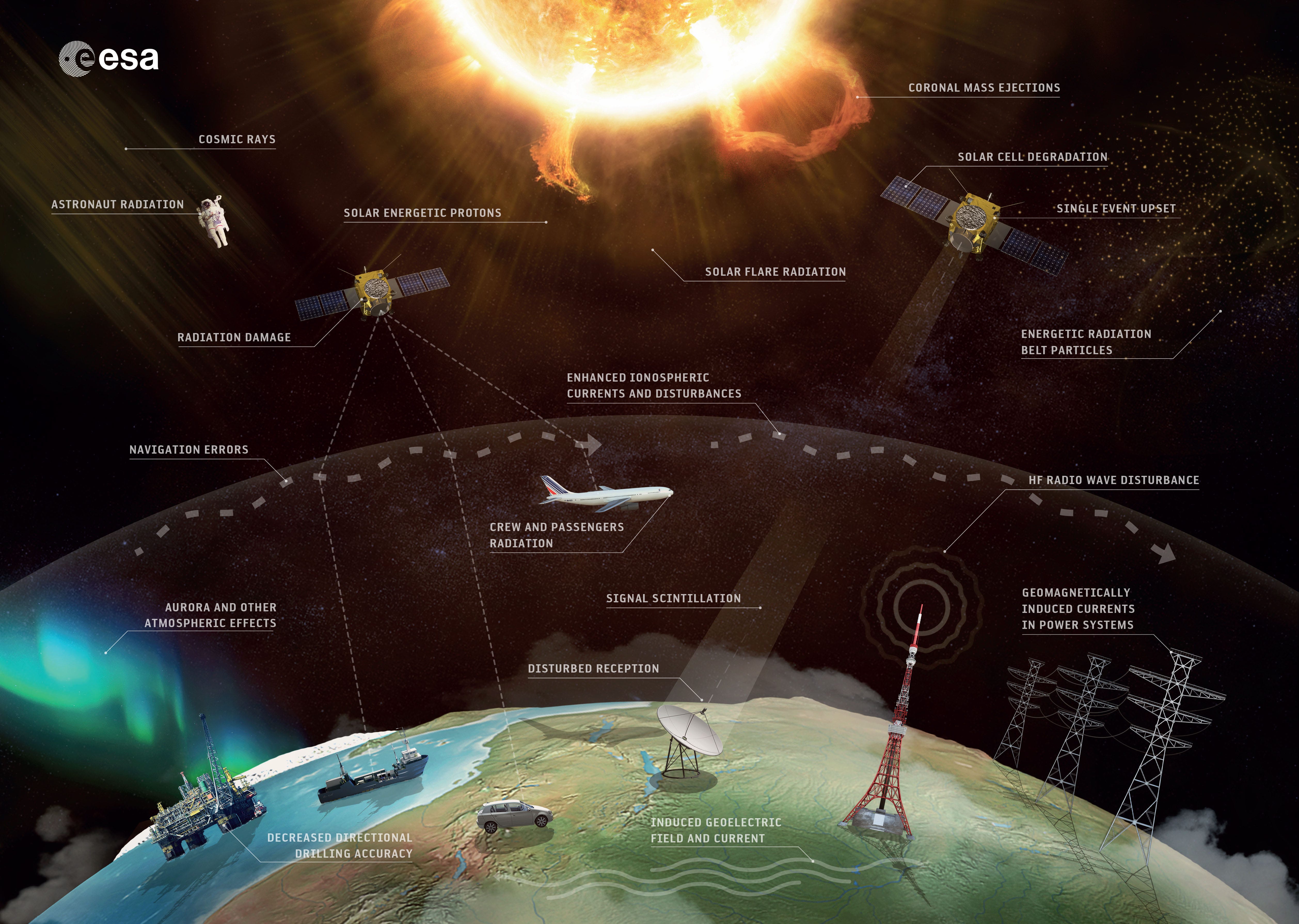
Science knows dozens of manifestations of space weather, but we won’t list them all — we’ll recall only those “hooligans” that actually spoil communications in Ukraine:
Solar flares — instant “spotlight flashes” in the X-ray and ultraviolet ranges. The ionosphere gets overloaded, and shortwaves go silent.
Coronal Mass Ejections (CMEs) — slow “plasma cannons.” A few days after such a shot, we get a geomagnetic storm.
Geomagnetic storms — the Earth’s magnetic field begins to “tremble,” and signals fly anywhere but where they should.
Solar proton events — streams of charged particles that damage aviation, satellites, and high-frequency systems.
To understand where we are most vulnerable, it is worth walking through the “radio building” floors — from slow giants at low frequencies to millimeter-wave satellite internet channels.
Low Floors: VLF / LF / MF (up to ≈3 MHz)
This is the oldest and slowest level. Here operate:
in VLF (3–30 kHz) — naval military communications, commands for submarines;
LF (30–300 kHz) — beacons and navigation systems of past decades;
MF (300–3000 kHz) — medium-wave AM radio, still audible in Ukraine, and some maritime and service channels.
Space weather here behaves like a “heavy carpet”: solar flares saturate the lower ionosphere with electrons, the wave fades, and broadcast range drops sharply.
Geomagnetic storms change the conductivity of the atmosphere — the signal is there, then gone. And ordinary thunderstorms add their “crackles,” which listeners sometimes mistake for a receiver problem.
The Long Road: HF (3–30 MHz)
HF is the real “long-haul trucker” of the ether. Here we have:
long-range military communications;
aviation on transcontinental routes (reserve channels);
maritime services and international calls;
shortwave amateur stations and broadcasting.
All this works thanks to the ionosphere: the wave reflects and travels thousands of kilometers. But this also makes HF the most vulnerable. A solar flare — and the D-layer becomes an impenetrable “wall”: communications disappear instantly for an hour or two. A geomagnetic storm — and the F-layer starts to wobble: channels that held yesterday collapse today. For aviation or the army, this can become a critical moment of radio silence.
Terrestrial weather hardly matters here: rain or fog mean nothing to HF. So when “shortwaves” are silent, don’t blame the clouds — blame the Sun.
Medium Distances: VHF (30–300 MHz)
This is the “workhorse level” for everyday tasks:
aviation “air–ground” communications (118–137 MHz);
FM radio (88–108 MHz);
tactical military and rescue radios.
In most cases, VHF is stable. But when the Earth’s magnetic field begins to tremble, the signal may “flicker,” like a voice on a faulty recorder. Occasionally anomalous propagation occurs — suddenly you hear a station from another region. Fun for radio amateurs, but an unexpected headache for an air traffic controller.
But ordinary thunderstorms hurt more here than space storms: lightning sends bursts of interference directly into the airwaves.
The Backbone of Modern Communications: UHF (300 MHz – 3 GHz)
This floor is the foundation of mobile technologies and everyday wireless solutions. Here operate:
mobile networks 2G/3G/4G/5G (700–3500 MHz);
digital terrestrial TV DVB-T2 (≈470–700 MHz);
military and service radios;
drone control and video channels: 433, 868, 915 MHz; 2.4 and 5.8 GHz.
Terrestrial cellular networks here are practically immune to space weather. But if the backhaul runs via satellite or a drone works on a satellite link, then a storm can add delays and packet loss.
Terrestrial factors are much more important: thunderstorms, tower damage, power outages.
The World of Satellites: SHF and Above (3–300 GHz)
Here begins the real “kitchen” of space and terrestrial weather:
L-band (1–2 GHz): GNSS and satellite phones. The most sensitive to space storms: GPS can be off by tens of meters.
S-band (2–4 GHz): telemetry and special services. Medium vulnerability.
C-band (4–8 GHz): classic VSAT, relatively resistant to rain.
X-band (8–12 GHz): military channels and radars. Balanced between stability and vulnerability.
Ku-band (12–18 GHz): satellite TV, VSAT, part of Starlink. Here storms may cause packet loss, but the main enemy is rain fade.
Ka-band (26–40 GHz): high-speed next-generation internet. Weak links are easily shaken by storms, while rain or wet snow simply “cut” the signal.
V-band and above (>40 GHz): the future. Even light rain can jam the channel, and space weather adds trouble.
All satellite systems are doubly vulnerable: solar storms from above, rain from below. And when electronic warfare (EW) is added, even experts may struggle to identify the cause of issues or outright communications loss.

By the way, the enemy knows this too and has already actively used anti-satellite EW systems during geomagnetic disturbances — both to increase the effect and to make detection and counteraction harder.
So What About Wi-Fi, Mobile Communications, and GPS Navigation?
While some answers were already given above, let’s specifically consider the impact of space weather on the most important technologies — because these are what people ask about most often :)
GNSS (GPS, Galileo, GLONASS) – the most vulnerable: during solar storms, ionospheric disruptions cause signals to “jump,” with errors growing to tens of meters. In strong disturbances, a receiver may simply “not hear” satellite signals at all.
Wi-Fi / Bluetooth / Zigbee, etc. – practically immune: they work over short distances and overpower any cosmic noise with signal strength. Even a strong storm will not disconnect your home router or headphones.
Mobile communications (2G–5G) – stable: terrestrial base stations and user devices hardly react to space weather. Main risks for networks are not from the Sun, but from power outages or infrastructure damage (especially where backhaul depends on satellites).
Satellite communications — Starlink, OneWeb, UASAT – since most operate in Ku/Ka bands, they have medium vulnerability: space weather causes “flickering” and packet loss, while ordinary terrestrial weather (rain, snow) further weakens the signal. It is important to note that “flat” terminals also depend on GNSS — they need precise coordinates to “aim” their beam at satellites.
So, space weather usually won’t disconnect your Bluetooth headphones, won’t break your Wi-Fi, and won’t shut down your mobile operator. But it can silence an aviation channel, “confuse” GPS, or take down satellite internet exactly when it is most needed.
How Can I Track Space Weather?
On SkyLinker you can subscribe to the space weather section, which we recently launched. There we publish alerts about space weather events worth attention and their impact on communications in Ukraine. For now, this is done “manually” — but we plan to build a more powerful and fully automated service. In addition, you can use the following sources:
NOAA / NWS Space Weather Prediction Center — the official center for space weather forecasts and status, with alerts on HF blackouts, geomagnetic storms, radio outages, etc. In particular, pay attention to:
TEC forecast map for Europe (Total Electron Content — the total number of electrons in the ionosphere), which affects HF radio propagation and especially GNSS (GPS, Galileo, GLONASS, BeiDou) accuracy.
Real-time TEC map of Europe, where you can see where and what GNSS errors are currently possible.
What Does This Mean for Warfare?
Nowhere else in the world are satellite communications and numerous other telecom solutions used on the battlefield at such scale — from tens of thousands of terminals on the frontline to the daily flights of hundreds of drones.
Until recently, the role of space weather in defense was simply underestimated. In recent years, there have been many episodes where a basic lack of understanding of this impact cost communications and… the lives of Ukrainian defenders. A particularly vivid example — the powerful geomagnetic storm of May 2024.
When planning a combat mission, any specialist must account for risks. When it comes to communications and GNSS, you must clearly identify risks, and you can evaluate and factor them in. Loss of Starlink connectivity, loss of drones, potential issues in long-range operations, etc. — all this can and should be anticipated and mitigated.
The SkyLinker project was created as an independent initiative by Volodymyr Stepanets, founder of the “Narodnyi Starlink” project and an initiator and participant in numerous volunteer MilTech projects of the past decade.
If you see value in the information and materials you receive on SkyLinker — support the project with a paid subscription. It is inexpensive and much clearer and more effective than donations: €50 per year or €5 per month.
We don’t want to flood you with tons of ads. We want to give you exactly what is useful and interesting to you. And a paid subscription is the best and most convenient solution. More importantly, your subscription supports and accelerates the creation of educational materials for the Defense Forces of Ukraine.
Of course, this material, like many others critically important for Ukraine’s defenders, will always be freely available. But paid subscribers will also gain access to analytical reports and unique reviews we prepare for everyone interested in the world of communications, space, and satellite technologies.